
This document contains the terms of use for…
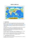
GEBCO's aim is to provide the most authoritative publicly-available bathymetry of the world's oceans. It operates under the joint auspices of the International Hydrographic Organization(IHO) and the Intergovernmental Oceanographic Commission (IOC) (of UNESCO).
GEBCO produces and makes available a range of bathymetric data sets and products. This includes a global bathymetric grid; gazetteer of undersea feature names, a Web Map Service and printable maps of ocean bathymetry.
Data and Resource
| Field | Value |
|---|---|
| Publisher | Secretariat of the Pacific Regional Environment Programme |
| Modified | |
| Release Date | |
| Source URL | https://www.gebco.net/ |
| Identifier | 7a9bb9fd-7d7d-47ef-afee-e094255e1262 |
| Spatial / Geographical Coverage Location | Pacific Region |
| Relevant Countries | Pacific Region |
| Language | English (United States) |
| License |
SPREP Public Licence
![[Open Data]](https://assets.okfn.org/images/ok_buttons/od_80x15_blue.png)
|
| Contact Name | GEBCO Data Officer |
| Contact Email | [email protected] |
| POD Theme | Coastal and Marine |