
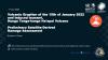
This map illustrates the impact of the Hunga…
This dataset contains preliminary impact assessments of the Hunga-Tonga-Hunga-Ha'apai volcanic eruption and induced tsunami in January 2022.
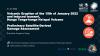
The eruptions sent a plume of ash, gas and steam 20 kilometers (12.4 miles) into the air. Satellite imagery showed a massive ash cloud and shockwaves spreading from the eruption. Ash was falling from the sky in the Tonga capital, Nuku'alofa, Saturday evening and phone connections were down. The eruption was likely the biggest recorded anywhere on the planet in more than 30 years, according to experts.
These are preliminary analysis detected from Pleiades images and have not yet been validated in the field
Sources for each study are mentioned in the description of each resource.
Data and Resource
UNOSAT Preliminary Assessment Report 'Eua Island - 21 Jan 2022
Preliminary Satellite-Derived Damage…
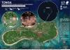
Damage assessment in Atata Island, Kolovao district, Tongatapu division, Tonga as of 18 January 2022
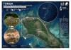
This map illustrates impact of the Hunga Tonga…
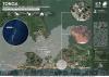
Damage assessment in Mango village-, Mu'omu'a District - 18 January 2022
This map illustrates effects of the Hunga-…
pdf
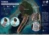
Damage assessment in Nomuka village- 18 January 2022
Damage assessment as detected from a Pleiades…
| Field | Value |
|---|---|
| Publisher | Secretariat of the Pacific Regional Environment Programme |
| Modified | |
| Release Date | |
| Source URL | https://disasterscharter.org/web/guest/activations/-/article/ocean-wave-in-tong… |
| Identifier | 93a311cd-fd29-4f81-b711-b09b5097edd8 |
| Spatial / Geographical Coverage Location | Tonga |
| Relevant Countries | Tonga |
| Language | English |
| License |
SPREP Public Licence
![[Open Data]](https://assets.okfn.org/images/ok_buttons/od_80x15_blue.png)
|
| Author | UNOSTAT/ The International Charter Space and Major Disasters |