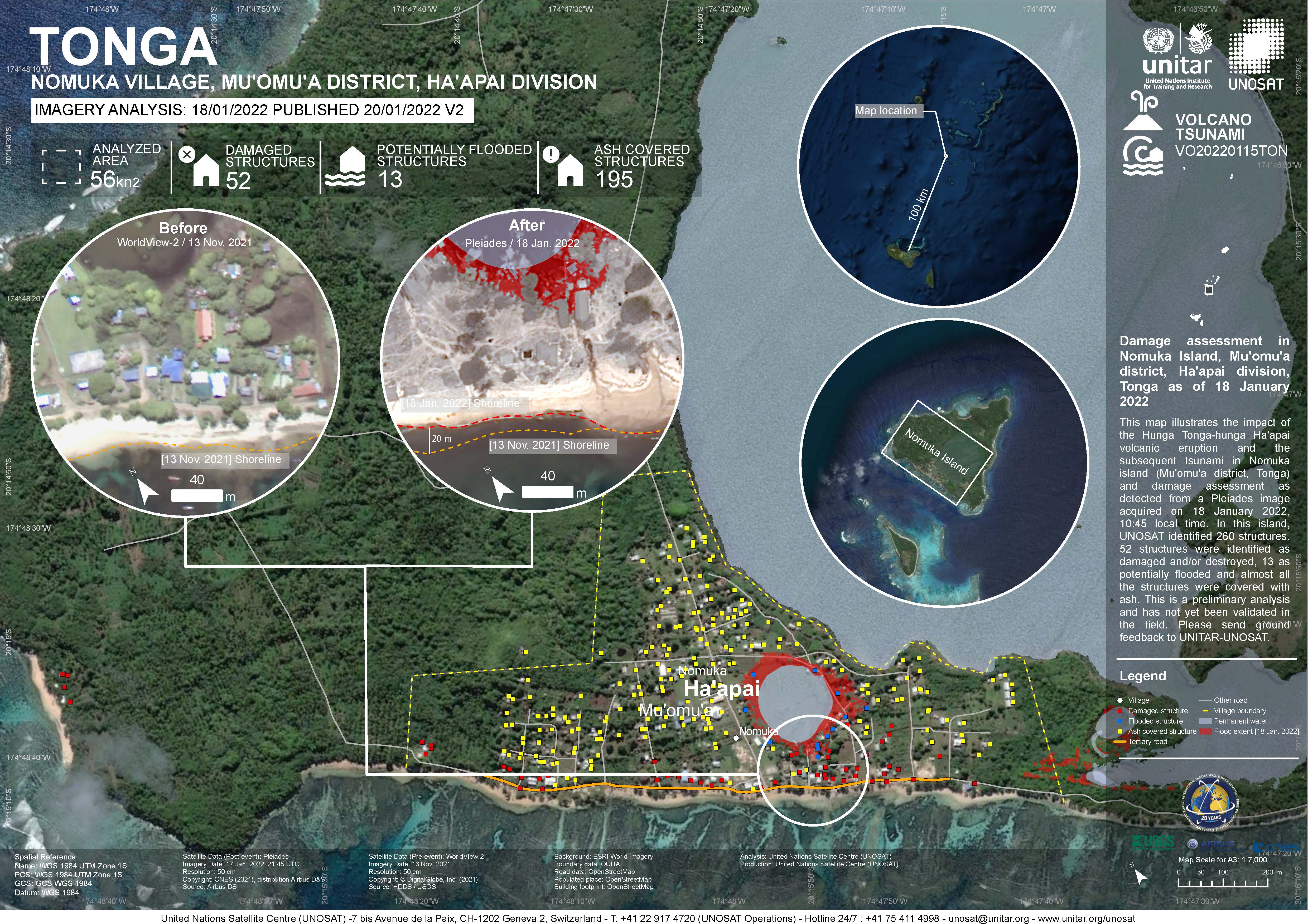
Damage assessment as detected from a Pleiades image acquired on 18 January 2022 in Nomuka Island (Mu'omu'a district, Tonga).
260 structures identified, 52 structures were identified as damaged and/or destroyed, 13 as potentially flooded and almost all structures were covered with ash. This is a preliminary analysis and has not yet been validated in the field

CVS version of the data in excel
CSV file containing the global distribution of hydrothermal vent fields in WGS84 coordinate system.
CSV file containing species richness values and mapping parameters for marine species (with a probability of occurrence > 0.5) derived from AquaMaps. A total of 33,512 species were used in the generation of this file.
Coordinate system is WGS84 (ESPG 4326) with coordinates expressed in longitude and latitude.
Fields in this file are:
C-Square Code: unique identifier for grid
Longitude: longitude in decimal degrees
Latitude: latitude in decimal degrees
Species Count: number of species modeled at given point
vegetation types within the mainland coastal region provinces
vegetation types for the provinces in the PNG highlands region
Each value represents the number of dumping events observed on fishing vessels during the period 2003-2015
This review was in preparation for Tonga's 4th national report to the CBD (Convention on Biological Diversity)
Official DKAN data portal user manual.
The Integrated Water and Coastal Management Plan for Vava'u acrhipelago in the Kingdom of Tonga has involved consultations with multi-level and multi-discipline stakeholder including local, provincial and national institutions, civil societies, private institutions and communities.
The Integrated Water and Coastal Management (IWCM) project was initiated in 2013 as a continuation of the very successful Integrated Water Resource Management Project in Vava'u from 2010-2012.
The deliverable focuses on a categorized listing of key issues and available information plus a concise description of the major characteristics of the Tongatapu coast (see Appendix B). The evidence to support the recommendations presented in this report has been gathered from a literature review, interviews with key stakeholders of Tongan government agencies and consideration of existing institutional practices of coastal management planning from the international arena (see Deliverable 2).
Rising oceans, changing lives: Final report is the overview report in a series of technical reports that have been
written for the project on Lifuka Island. Accordingly the section titles in the final report correspond with the
names of the respective technical reports.
This was an integrated effort by all concerned with the coastline in Tonga.
Integrated Coastal management applied conscious management process that acknowledge the interrelationships among most coastal and ocean uses and the environment that potentially affected.
A presentation by Mr Taaniela Kula - from the "Groundwater Governance: a Global Framework for Action"
An evaluation of water and sanitation in The Kingdom of Tonga, July 2011
The National Water, Sanitation and Climate Outlook for TOnga identifies the Government's and other stakeholder's priorities to address driving forces of change in these key areas. It is one of many steps required to guide the development and security of a safe water supply and sanitation facilities for the future of Tonga, and will ensure that efforts are focused on supporting sustainable development of water resources for all Tongans.
The study was a remarkably productive and enriching experience for all who were involved. It became a forum for critical reflections and analysis. It also built a knowledge and understanding amongst different communities, villages and the survey team.
Water Resources Report 1992, Appendices A-H
Water Resources Report 1992, Appendices I-K