Raster data representing the mean levels of temperature in degrees Celsius (°C) for the surface water layer. The data are available for global-scale applications at a spatial resolution of 5 arcmin (approximately 9.2 km at the equator).
Marine data layers for present conditions were produced with climate data describing monthly averages for the period 2000–2014, obtained from pre-processed global ocean re-analyses combining satellite and in situ observations at regular two- and three-dimensional spatial grids.
The Gridded Population of the World, Version 4 (GPWv4): Population Density, Revision 11 consists of estimates of human population density (number of persons per square kilometer) based on counts consistent with national censuses and population registers, for the years 2000. A proportional allocation gridding algorithm, utilizing approximately 13.5 million national and sub-national administrative units, was used to assign population counts to 30 arc-second grid cells.
The Gridded Population of the World, Version 4 (GPWv4): Population Density, Revision 11 consists of estimates of human population density (number of persons per square kilometer) based on counts consistent with national censuses and population registers, for the year 2005. A proportional allocation gridding algorithm, utilizing approximately 13.5 million national and sub-national administrative units, was used to assign population counts to 30 arc-second grid cells.
The Gridded Population of the World, Version 4 (GPWv4): Population Density, Revision 11 consists of estimates of human population density (number of persons per square kilometer) based on counts consistent with national censuses and population registers, for the year 2010. A proportional allocation gridding algorithm, utilizing approximately 13.5 million national and sub-national administrative units, was used to assign population counts to 30 arc-second grid cells.
The Gridded Population of the World, Version 4 (GPWv4): Population Density, Revision 11 consists of estimates of human population density (number of persons per square kilometer) based on counts consistent with national censuses and population registers, for the year 2015. A proportional allocation gridding algorithm, utilizing approximately 13.5 million national and sub-national administrative units, was used to assign population counts to 30 arc-second grid cells.
The Gridded Population of the World, Version 4 (GPWv4): Population Density, Revision 11 consists of estimates of human population density (number of persons per square kilometer) based on counts consistent with national censuses and population registers, for the year 2020. A proportional allocation gridding algorithm, utilizing approximately 13.5 million national and sub-national administrative units, was used to assign population counts to 30 arc-second grid cells.
The increased demand for high quality products in export markets, coupled with Pacific Island Countries (PICs) national desire to protect the environment, biodiversity and family farming structures, lead to assume that organic agriculture could offer good prospects for PICs development. Besides market opportunities, organic agriculture could increase PICs food self-reliance and thus, contribute to reducing the alarming trend of dependency on food imports, as well as improving nutrition.
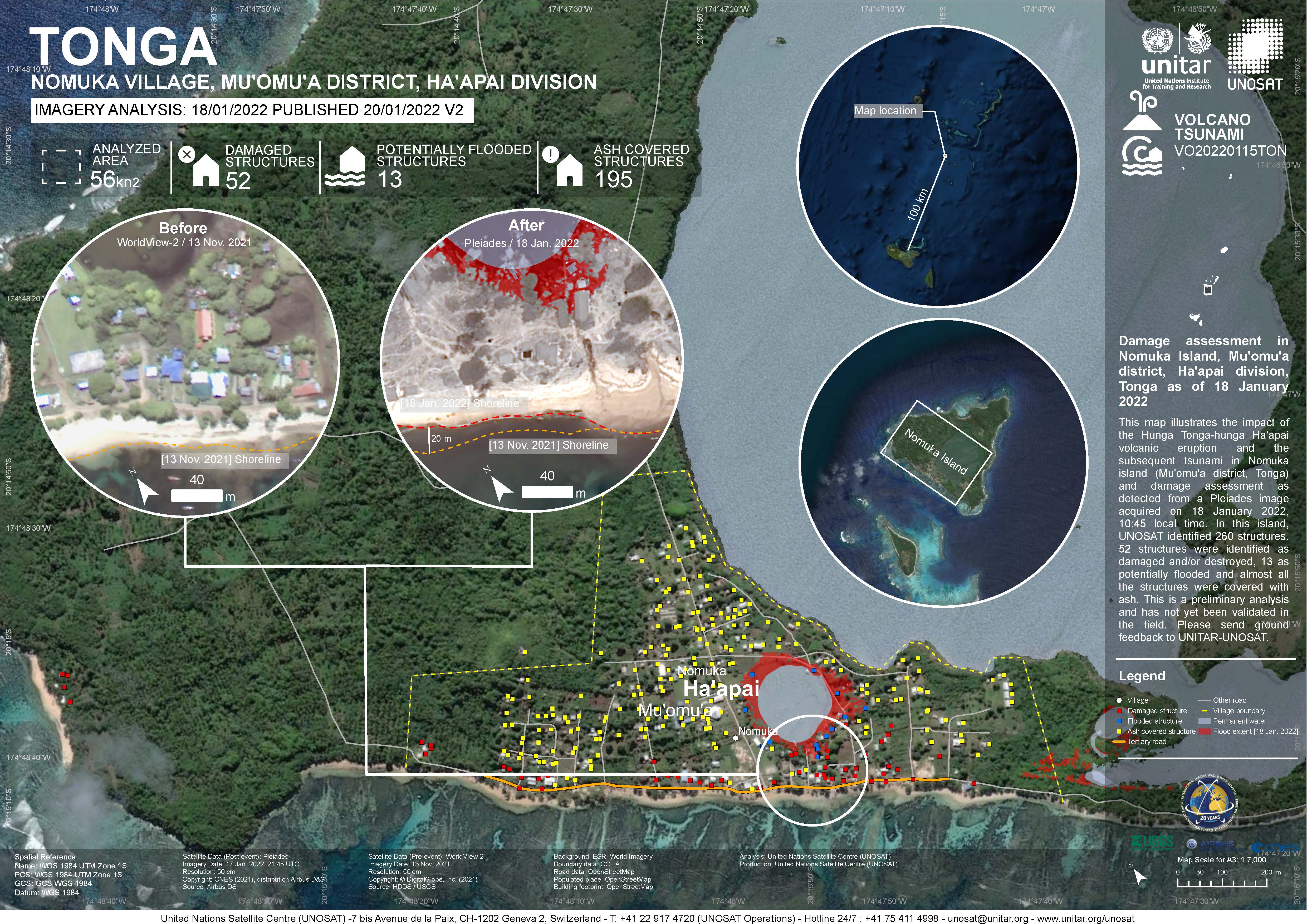
Damage assessment as detected from a Pleiades image acquired on 18 January 2022 in Nomuka Island (Mu'omu'a district, Tonga).
260 structures identified, 52 structures were identified as damaged and/or destroyed, 13 as potentially flooded and almost all structures were covered with ash. This is a preliminary analysis and has not yet been validated in the field

This review was in preparation for Tonga's 4th national report to the CBD (Convention on Biological Diversity)
Official DKAN data portal user manual.
The Integrated Water and Coastal Management Plan for Vava'u acrhipelago in the Kingdom of Tonga has involved consultations with multi-level and multi-discipline stakeholder including local, provincial and national institutions, civil societies, private institutions and communities.
The Integrated Water and Coastal Management (IWCM) project was initiated in 2013 as a continuation of the very successful Integrated Water Resource Management Project in Vava'u from 2010-2012.
The deliverable focuses on a categorized listing of key issues and available information plus a concise description of the major characteristics of the Tongatapu coast (see Appendix B). The evidence to support the recommendations presented in this report has been gathered from a literature review, interviews with key stakeholders of Tongan government agencies and consideration of existing institutional practices of coastal management planning from the international arena (see Deliverable 2).
Rising oceans, changing lives: Final report is the overview report in a series of technical reports that have been
written for the project on Lifuka Island. Accordingly the section titles in the final report correspond with the
names of the respective technical reports.
This was an integrated effort by all concerned with the coastline in Tonga.
Integrated Coastal management applied conscious management process that acknowledge the interrelationships among most coastal and ocean uses and the environment that potentially affected.
A presentation by Mr Taaniela Kula - from the "Groundwater Governance: a Global Framework for Action"
An evaluation of water and sanitation in The Kingdom of Tonga, July 2011
The National Water, Sanitation and Climate Outlook for TOnga identifies the Government's and other stakeholder's priorities to address driving forces of change in these key areas. It is one of many steps required to guide the development and security of a safe water supply and sanitation facilities for the future of Tonga, and will ensure that efforts are focused on supporting sustainable development of water resources for all Tongans.
The study was a remarkably productive and enriching experience for all who were involved. It became a forum for critical reflections and analysis. It also built a knowledge and understanding amongst different communities, villages and the survey team.