MEA icons for : SDG and Aichi targets
OpenStreetMap (OSM) is a free, editable map & spatial database of the whole world. This dataset is an extract of OpenStreetMap data for Tonga in a GIS-friendly format.
The OSM data has been split into separate layers based on themes (buildings, roads, points of interest, etc), and it comes bundled with a QGIS project and styles, to help you get started with using the data in your maps. This OSM product will be updated weekly.
The World Database on Protected Areas (WDPA) is the most comprehensive global database of marine and terrestrial protected areas, updated on a monthly basis, and is one of the key global biodiversity data sets being widely used by scientists, businesses, governments, International secretariats and others to inform planning, policy decisions and management.
Shapefiles to be used for the GIS training facilitated by EMG for all staff.
Dates : 8 - 9 November 2021
to be deleted
This dataset has all icons for Multilateral Environment Agreements such as SDGs and Aichi
Various training and reference materials from the ACPMEA and Inform Joint Regional Meeting held at SPREP 17-21 September 2018.
These instructional videos walk users through the portal and its different features.
Documentation on getting started with the Inform Data Portal
Photos from the meeting....
State of Environment (SoE) reports provide in-country partners with a process to gather data on current environmental indicators, document their status, and formulate a plan for keeping these indicators on track or developing policies and programs as needed. This SoE Toolkit dataset contains resources that serve as guides to help create up-to-date State of Environment reports.
The Strandings of Oceania database is a collaborative project between SPREP, WildMe and the South Pacific Whale Research Consortium to record stranding and beachcast data for whales, dolphins and dugongs throughout the Pacific. We use a platform called Flukebook. An account is needed to view or use data within Flukebook but the data is available for download here. You can submit data direct into Flukebook (preferably while logged in) or send a completed data form to SPREP for upload. Guidance on using the database is available :
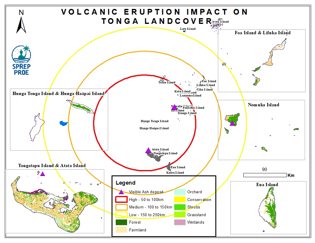
This dataset contains all spatial data that is related to the Tonga volcanic eruption. Maps produced are derived from credible data source such as UNOSTAT and UNITAR.

The ASTER Global Digital Elevation Model (GDEM) Version 3 (ASTGTM) provides a global digital elevation model (DEM) of land areas on Earth at a spatial resolution of 1 arc second (approximately 30 meter horizontal posting at the equator).
The development of the ASTER GDEM data products is a collaborative effort between National Aeronautics and Space Administration (NASA) and Japan’s Ministry of Economy, Trade, and Industry (METI). The ASTER GDEM data products are created by the Sensor Information Laboratory Corporation (SILC) in Tokyo.
SENTINEL-2 is a wide-swath, high-resolution, multi-spectral imaging mission, supporting Copernicus Land Monitoring studies, including the monitoring of vegetation, soil and water cover, as well as observation of inland waterways and coastal areas.
The SENTINEL-2 Multispectral Instrument (MSI) samples 13 spectral bands: four bands at 10 metres, six bands at 20 metres and three bands at 60 metres spatial resolution.
This dataset holds all media resources for the State of Environment and Conservation in the Pacific Islands: 2020 Regional Report
raw rainfall data collected in 2016
OpenStreetMap (OSM) is a free, editable map & spatial database of the whole world. This dataset is an extract of OpenStreetMap data for Wallis and Futuna in a GIS-friendly format.
The OSM data has been split into separate layers based on themes (buildings, roads, points of interest, etc), and it comes bundled with a QGIS project and styles, to help you get started with using the data in your maps. This OSM product will be updated weekly.