Provides principles to support nature conservation in pacific islands
This guide introduces environmental indicators and provides an overview of SPREP’S core indicators for Pacific island countries. In 2012, the SPREP members approved the development of a set of standardised indicators for use by member countries at the SPREP meeting. Through the Inform project, SPREP programmes then developed a set of 34 indicators that was endorsed by members at the 2018 SPREP meeting. This document explains the development and use of environmental indicators in Part 1 and provides a summary of each of the 34 ‘core’ indicators in Part 2.
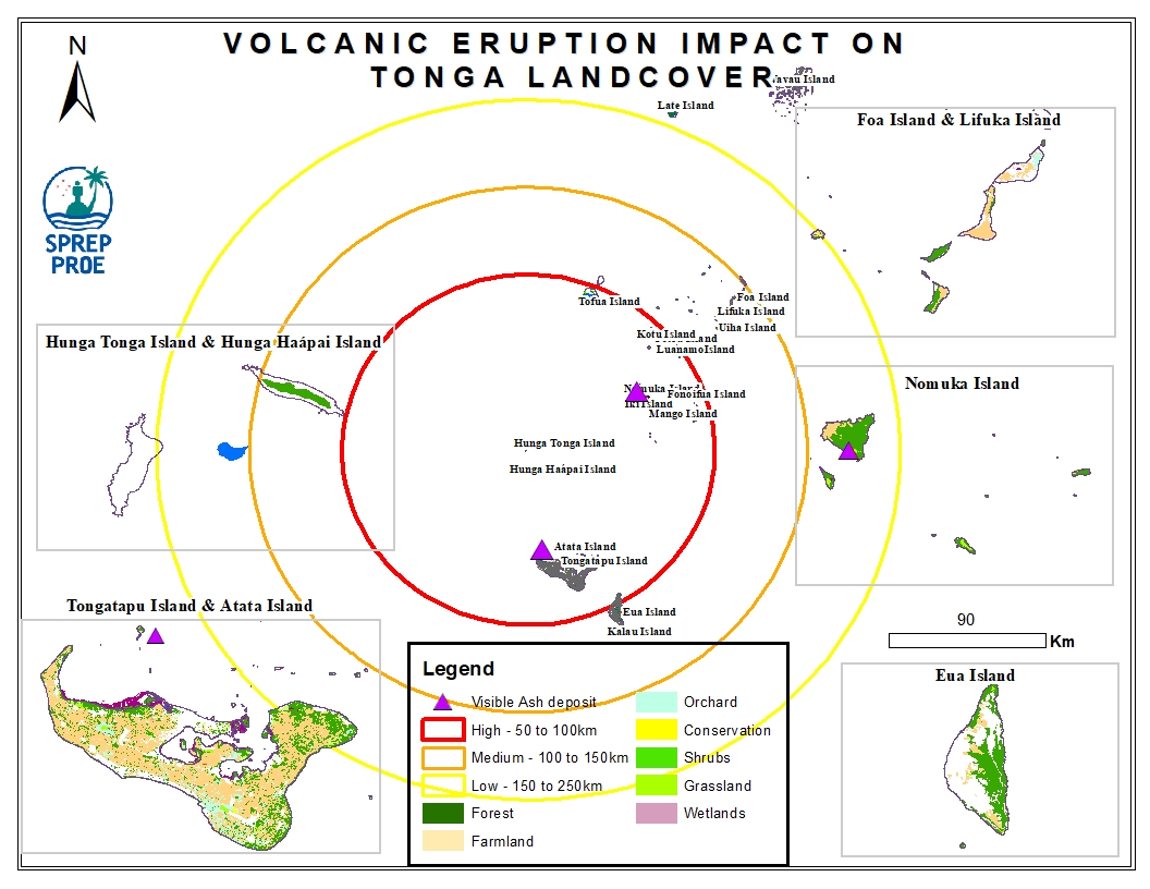
The Hunga Tonga-Hunga Ha'apai massive undersea volcanic eruption occurred on the 15th of January 2022 and led to an induced tsunami event. The eruption triggered a tsunami warning for several South Pacific island nations with rising water levels were reported on the coastline of Peru and the Pacific Coast in the United States and caused devastating impact across Tonga. In addition, volcanic ash residue was also visible on land surfaces including building structures and surrounding vegetation.
This dataset contains preliminary impact assessments of the Hunga-Tonga-Hunga-Ha'apai volcanic eruption and induced tsunami in January 2022.
The eruptions sent a plume of ash, gas and steam 20 kilometers (12.4 miles) into the air. Satellite imagery showed a massive ash cloud and shockwaves spreading from the eruption. Ash was falling from the sky in the Tonga capital, Nuku'alofa, Saturday evening and phone connections were down. The eruption was likely the biggest recorded anywhere on the planet in more than 30 years, according to experts.
This dataset contains all spatial data that is related to the Tonga volcanic eruption. Maps produced are derived from credible data source such as UNOSTAT and UNITAR.

Circular 21/150
Inform Plus proposed 5 pillars
- Component 1: Environmental Governance
- Component 2: Monitoring and field data collection for environmental standards and standardised environmental indicators
- Component 3: Data management utilising the Pacific Island Network Portal (PEP). Production of information products for decision makers based on existing data sets.
- Component 4: Enhance and expand GIS use for data collection, analysis and presentation to inform decision makers
This study reports the concentration of the metals, such as Cd, Co, Cr, Ni, Cu, Pb, Zn, and Fe, in the road dust and the roadside soil of Suva City. A total number of 45 road dust and 36 roadside soil samples were collected at 18 different locations around Suva City with potential traffic influence and analysed.
Summary table of the status of Pacific Island countries in relation to International and Regional conventions.