Marine waste from Pacific Island Countries
FAO Agriculture and Fair Trade in Pacific Island Countries. This desk study has been prepared by Winnie Fay Bell and comments were kindly provided by the Pacific Regional Organic Task Force in May 2009
This is the report for the Reefs at Risk Revisited analysis. Reefs at Risk Revisited is a high-resolution update of the original global analysis, Reefs at Risk: A Map-Based Indicator of Threats to the World’s Coral Reefs. Reefs at Risk Revisited uses a global map of coral reefs at 500-m resolution, which is 64 times more detailed than the 4-km resolution map used in the 1998 analysis, and benefits from improvements in many global data sets used to evaluate threats to reefs (most threat data are at 1 km resolution, which is 16 times more detailed than those used in the 1998 analysis).
The increased demand for high quality products in export markets, coupled with Pacific Island Countries (PICs) national desire to protect the environment, biodiversity and family farming structures, lead to assume that organic agriculture could offer good prospects for PICs development. Besides market opportunities, organic agriculture could increase PICs food self-reliance and thus, contribute to reducing the alarming trend of dependency on food imports, as well as improving nutrition.
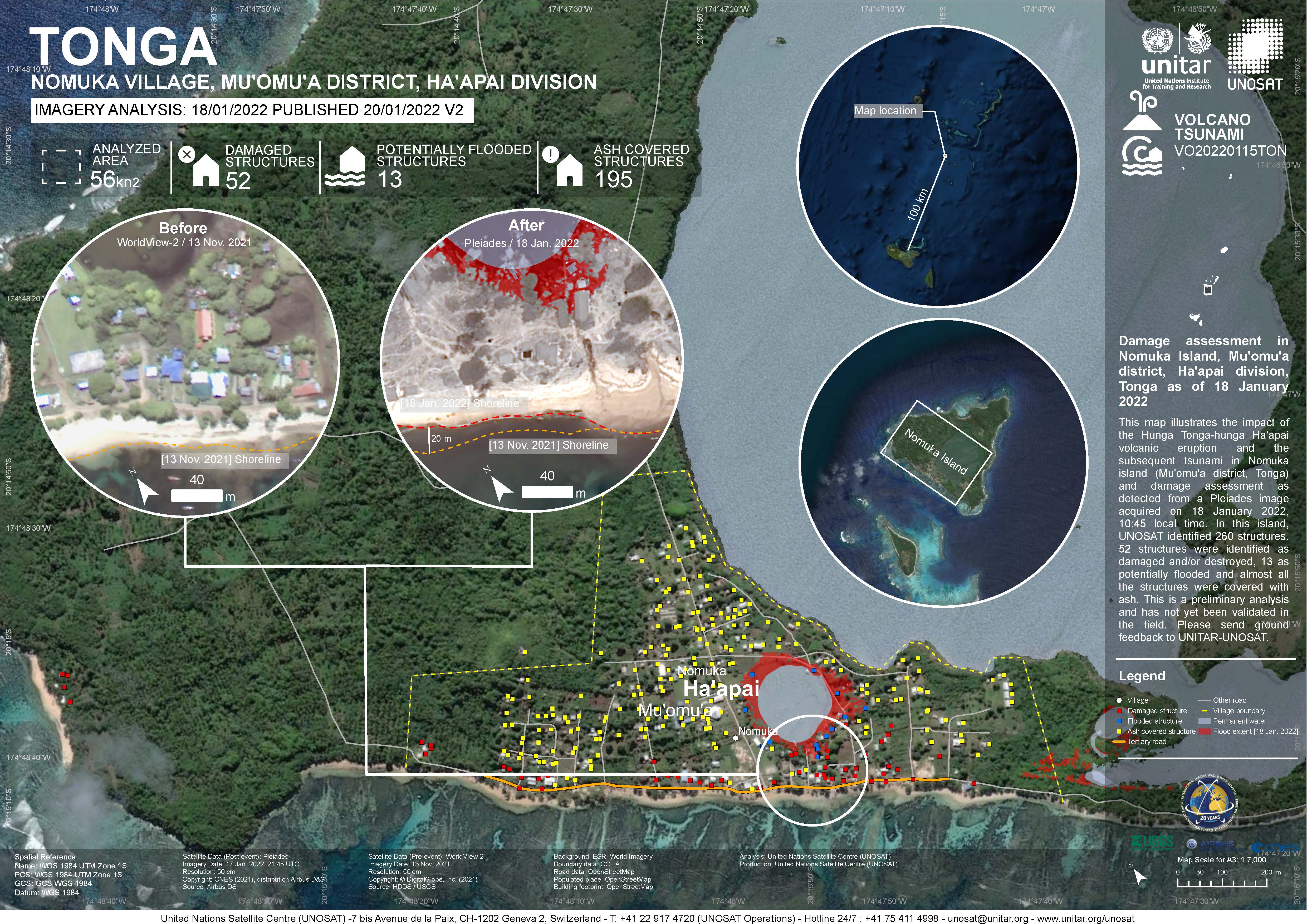
Damage assessment as detected from a Pleiades image acquired on 18 January 2022 in Nomuka Island (Mu'omu'a district, Tonga).
260 structures identified, 52 structures were identified as damaged and/or destroyed, 13 as potentially flooded and almost all structures were covered with ash. This is a preliminary analysis and has not yet been validated in the field

CVS version of the data in excel
Reefs at Risk Revisited is a high-resolution update of the original global analysis, Reefs at Risk: A Map-Based Indicator of Threats to the World’s Coral Reefs. Reefs at Risk Revisited uses a global map of coral reefs at 500-m resolution, which is 64 times more detailed than the 4-km resolution map used in the 1998 analysis, and benefits from improvements in many global data sets used to evaluate threats to reefs (most threat data are at 1 km resolution, which is 16 times more detailed than those used in the 1998 analysis).
CSV file containing the global distribution of hydrothermal vent fields in WGS84 coordinate system.
CSV file containing species richness values and mapping parameters for marine species (with a probability of occurrence > 0.5) derived from AquaMaps. A total of 33,512 species were used in the generation of this file.
Coordinate system is WGS84 (ESPG 4326) with coordinates expressed in longitude and latitude.
Fields in this file are:
C-Square Code: unique identifier for grid
Longitude: longitude in decimal degrees
Latitude: latitude in decimal degrees
Species Count: number of species modeled at given point
AquaMaps are computer-generated predictions of natural occurrence of marine species, based on the environmental tolerance of a given species with respect to depth, salinity, temperature, primary productivity, and its association with sea ice or coastal areas. These 'environmental envelopes' are matched against an authority file which contains respective information for the Oceans of the World. Independent knowledge such as distribution by FAO areas or bounding boxes are used to avoid mapping species in areas that contain suitable habitat, but are not occupied by the species.
vegetation types within the mainland coastal region provinces
vegetation types for the provinces in the PNG highlands region
Each value represents the number of dumping events observed on fishing vessels during the period 2003-2015
This document is a review of the status, trends and threats to Tonga’s unique biodiversity since the inception of its own NBSAP in 2006. The review also covers the status of the implementation of objectives and action plans, sectors and cross sector collaboration.
Final draft document of the national water and coastal management plan for Vavau
This is part of the "Preparation of Diagnostic Study to Inform an Integrated Coastal Management Plan for Tongatapu, Tonga" - this document represents Deliverable 3 : Coastal Characteristics and Issues Report