direct internet link to Tonga's climate change data portal.
FAO Agriculture and Fair Trade in Pacific Island Countries. This desk study has been prepared by Winnie Fay Bell and comments were kindly provided by the Pacific Regional Organic Task Force in May 2009
End of Internship presentation on Pacific Climate Finance. Section are: climate finance challenges, overview of climate finance in the Pacific, and next steps.
This is the report for the Reefs at Risk Revisited analysis. Reefs at Risk Revisited is a high-resolution update of the original global analysis, Reefs at Risk: A Map-Based Indicator of Threats to the World’s Coral Reefs. Reefs at Risk Revisited uses a global map of coral reefs at 500-m resolution, which is 64 times more detailed than the 4-km resolution map used in the 1998 analysis, and benefits from improvements in many global data sets used to evaluate threats to reefs (most threat data are at 1 km resolution, which is 16 times more detailed than those used in the 1998 analysis).
PowerPoint presentation on the building blocks and features of the environment data portals.
PowerPoint presentation with tips on good practices, when uploading data to the environment data portals.
The increased demand for high quality products in export markets, coupled with Pacific Island Countries (PICs) national desire to protect the environment, biodiversity and family farming structures, lead to assume that organic agriculture could offer good prospects for PICs development. Besides market opportunities, organic agriculture could increase PICs food self-reliance and thus, contribute to reducing the alarming trend of dependency on food imports, as well as improving nutrition.
End of SPREP internship presentation, July 2015. Sections: climate finance challenges, overview of climate finance in the Pacific, and next steps.
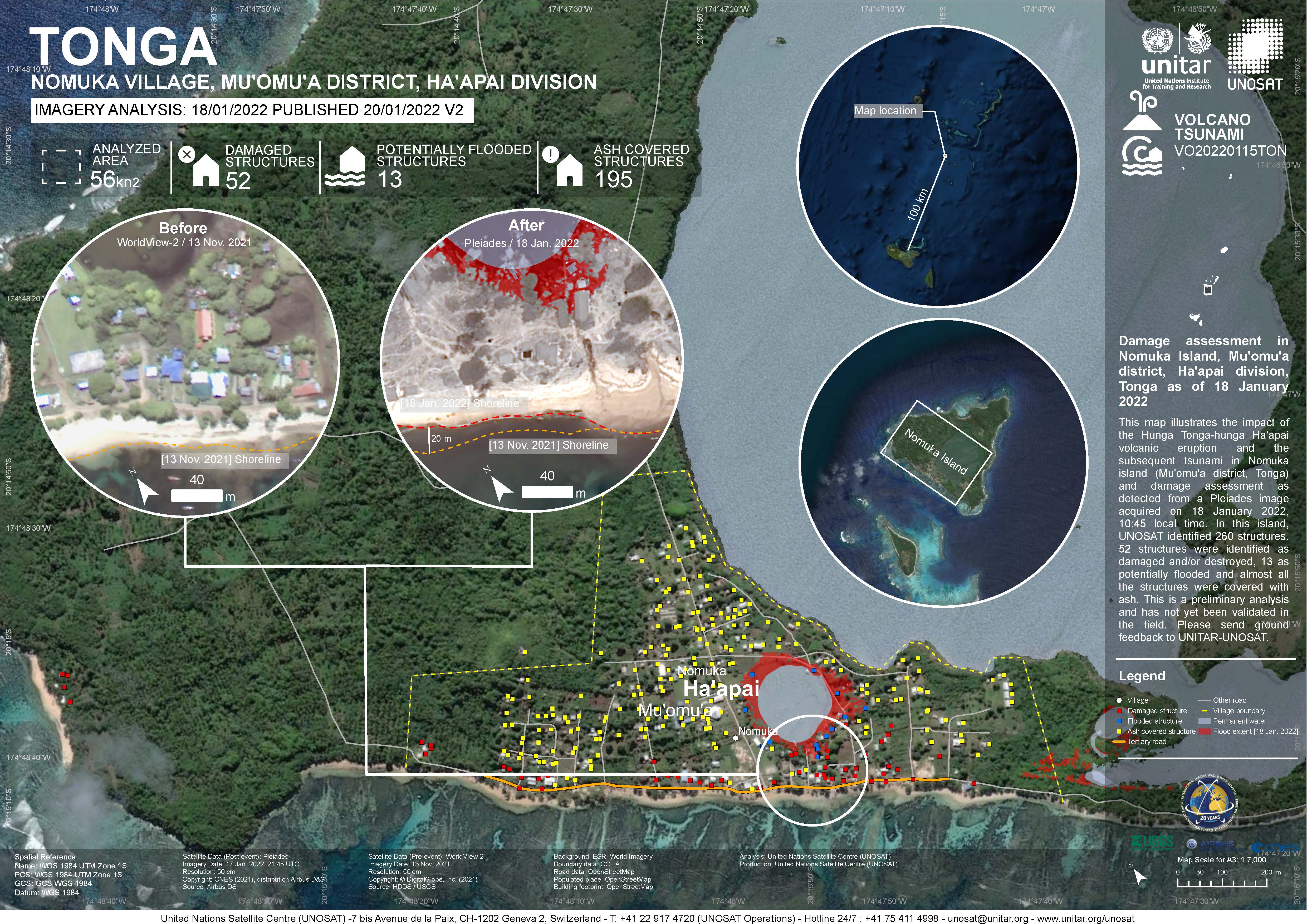
Damage assessment as detected from a Pleiades image acquired on 18 January 2022 in Nomuka Island (Mu'omu'a district, Tonga).
260 structures identified, 52 structures were identified as damaged and/or destroyed, 13 as potentially flooded and almost all structures were covered with ash. This is a preliminary analysis and has not yet been validated in the field

direct link to species occurrences in Tonga on the GBIF website
A collection of Inform project training materials. You are free to download and use any of the training resources below. The PowerPoint presentations contain a complete set of slides, so please feel free to copy, delete or change slides, to fit the purpose of your country training.
This dataset contains templates of policies and MoU's on data sharing.
You can download the Word-templates and adapt the documents to your national context.
At the end of a training, you can ask participants to fill in this Action Plan. The goal is to link learning to performance.
This policy applies requests for data held by a Ministry. The purpose of this policy is to:
• encourage the free exchange of data within a Ministry, with other government agencies within the country and with the public, as appropriate
• ensure that sensitive information (including commercially sensitive data) held by the Ministry is not compromised.
Memorandum of Understanding between two parties, for the exchange of data, related information and other services.