Several GIS file types illustrating Tongan Coral reef geomorphic structure
Data originally produced by Millennium Coral Reef Mapping Project validated maps provided by the Institute for Marine Remote Sensing, University of South Florida (IMaRS/USF) and Institut de Recherche pour le Développement (IRD, Centre de Nouméa), with support from NASA.
Dataset that provides a direct link to Tonga's data hosted on the GBIF website/ records.
Dataset that provides a direct internet link to Tonga's climate change data portal.
The World Database on Protected Areas (WDPA) is the most comprehensive global database of marine and terrestrial protected areas, updated on a monthly basis, and is one of the key global biodiversity data sets being widely used by scientists, businesses, governments, International secretariats and others to inform planning, policy decisions and management.
direct internet link to Tonga's climate change data portal.
FAO Agriculture and Fair Trade in Pacific Island Countries. This desk study has been prepared by Winnie Fay Bell and comments were kindly provided by the Pacific Regional Organic Task Force in May 2009
This is the report for the Reefs at Risk Revisited analysis. Reefs at Risk Revisited is a high-resolution update of the original global analysis, Reefs at Risk: A Map-Based Indicator of Threats to the World’s Coral Reefs. Reefs at Risk Revisited uses a global map of coral reefs at 500-m resolution, which is 64 times more detailed than the 4-km resolution map used in the 1998 analysis, and benefits from improvements in many global data sets used to evaluate threats to reefs (most threat data are at 1 km resolution, which is 16 times more detailed than those used in the 1998 analysis).
The increased demand for high quality products in export markets, coupled with Pacific Island Countries (PICs) national desire to protect the environment, biodiversity and family farming structures, lead to assume that organic agriculture could offer good prospects for PICs development. Besides market opportunities, organic agriculture could increase PICs food self-reliance and thus, contribute to reducing the alarming trend of dependency on food imports, as well as improving nutrition.
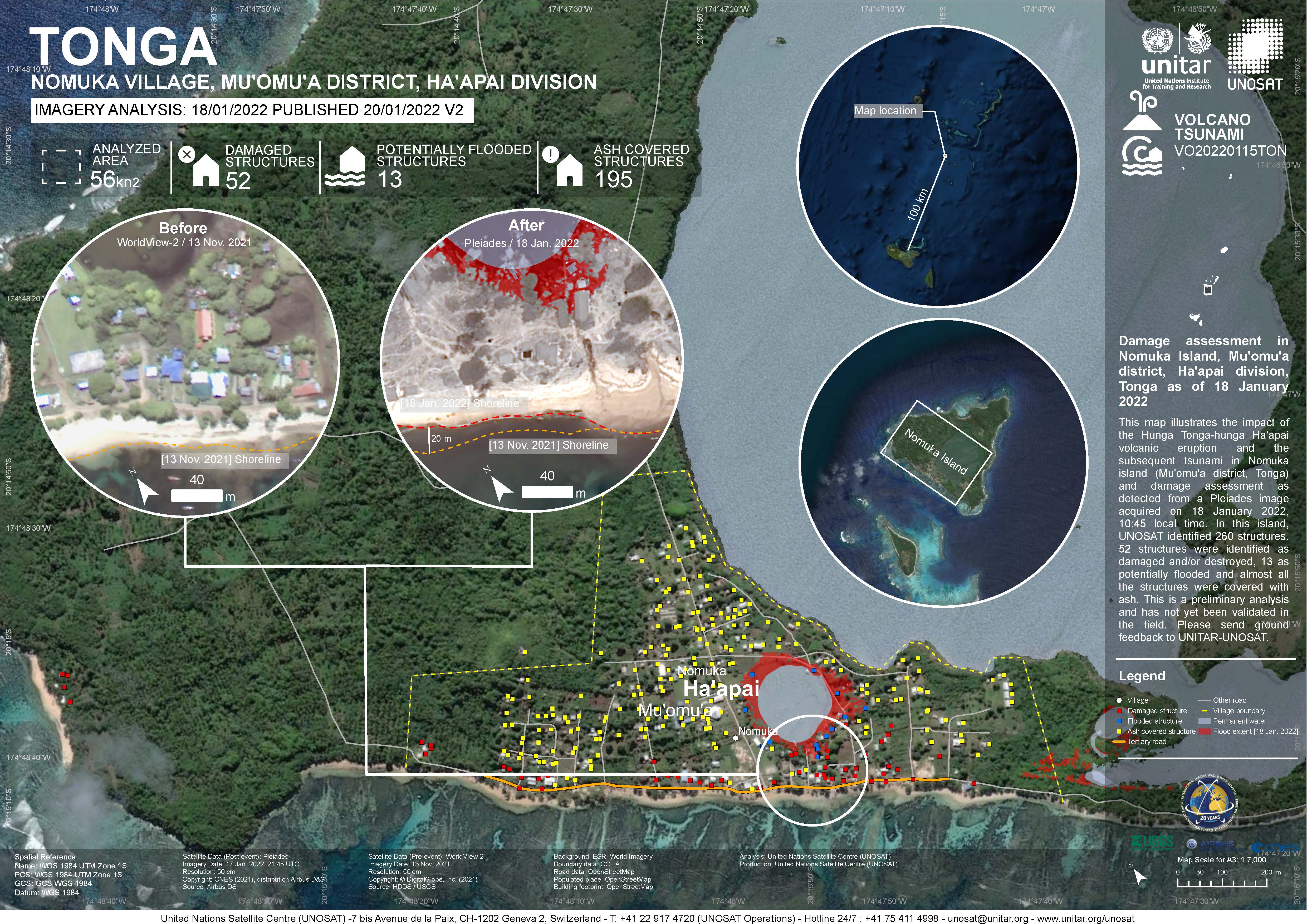
Damage assessment as detected from a Pleiades image acquired on 18 January 2022 in Nomuka Island (Mu'omu'a district, Tonga).
260 structures identified, 52 structures were identified as damaged and/or destroyed, 13 as potentially flooded and almost all structures were covered with ash. This is a preliminary analysis and has not yet been validated in the field

direct link to species occurrences in Tonga on the GBIF website
Reefs at Risk Revisited is a high-resolution update of the original global analysis, Reefs at Risk: A Map-Based Indicator of Threats to the World’s Coral Reefs. Reefs at Risk Revisited uses a global map of coral reefs at 500-m resolution, which is 64 times more detailed than the 4-km resolution map used in the 1998 analysis, and benefits from improvements in many global data sets used to evaluate threats to reefs (most threat data are at 1 km resolution, which is 16 times more detailed than those used in the 1998 analysis).
Dataset includes various regional-scale spatial data layers in geojson format.
This document is a review of the status, trends and threats to Tonga’s unique biodiversity since the inception of its own NBSAP in 2006. The review also covers the status of the implementation of objectives and action plans, sectors and cross sector collaboration.
Final draft document of the national water and coastal management plan for Vavau
This is part of the "Preparation of Diagnostic Study to Inform an Integrated Coastal Management Plan for Tongatapu, Tonga" - this document represents Deliverable 3 : Coastal Characteristics and Issues Report
This vulnerability assessment provides evidence for the Government of Tonga and the people of Lifuka Island to make informed decisions about adapting to coastal erosion and sea-level rise. This project also aimed to be a blueprint for other low-lying nations considering adaptation options.
The objectives of this study were as follows:
1. Resurvey and delineation of the sand resource of eight beaches on Tongatapu
2. Evaluation of the extent of recent coastal changes on Tongatapu including changes effected by cyclones and other natural events, beach sand extraction, and interaction between the two.
3. Investigation of the rate of sand production and implications for the sustainability of beach mining.