This guide introduces environmental indicators and provides an overview of SPREP’S core indicators for Pacific island countries. In 2012, the SPREP members approved the development of a set of standardised indicators for use by member countries at the SPREP meeting. Through the Inform project, SPREP programmes then developed a set of 34 indicators that was endorsed by members at the 2018 SPREP meeting. This document explains the development and use of environmental indicators in Part 1 and provides a summary of each of the 34 ‘core’ indicators in Part 2.
This summary of all current literature on violence against women in the pacific region, is designed to give practitioners a concise and comprehensive overview of current knowledge and analysis. The evidence presented in this first edition presents a compelling case for more action and investment in preventing and responding to violence against women. It is intended to inform leaders, legislators, policy makers and other key decision makers in government and programme designers in government and civil society.
The 43rd edition, the Key Indicators for Asia and the Pacific 2012 (Key Indicators 2012) continues to provide a set of comprehensive social, economic, financial, environmental, and Millennium Development Goals (MDGs) indicator series for the 48 regional members. The Key Indicators provides a timely and reliable source of data and information for policy makers, development practitioners, government officials, researchers, students, and the general public. For the second year, the Framework of Inclusive Growth Indicators supplements the main Key Indicators publication.
This
paper presents the findings from the first comprehensive study of pooling initiatives in the
Pacific. It draws on a review of the literature pertaining to all 20 pooling initiatives identified in
the region, and on interviews of stakeholders involved in many of those initiatives. The study
finds that experience with pooling among Pacific SIDS has not met the optimistic expectations
of advocates, including development partners. This is the result of the challenges inherent in
Papers, case studies, research results and conversations about rapid urbanisation in the Pacific and the hopes, experiences and adjustments people make to living in town. Publication of this issue was supported by the State, Society and Governance in Melanesia Program (SSGM) at the Australian National University. SSGM is the leading international centre for applied multidisciplinary research and analysis concerning contemporary state, society and governance issues in Melanesia and the broader Pacific.
It is a one page poster which reflects the outcomes of the 2007 Alotau conference and provides principles and critical components to deliver nature conservation in the pacific.
Refer to dataset description for information. Please use this version for double-sided printing.
Please refer to dataset description for further information.
Situation overview of the Tonga Volcanic eruption as of 16th January 2022.
Situation overview for the Tonga volcanic eruption as of 17th January 2022.
Situation overview for the Tonga volcanic eruption as of 18th January 2022.
The map shows the location of the Hunga Tonga - Hunga Ha’apai volcanoe in relation to the surrounding pacific island countries.
Damage assessment in Atata Island, Kolovao district, Tongatapu division, Tonga as of 18 January 2022
This map illustrates impact of the Hunga Tonga-hunga Ha'apai volcanic eruption and subsequent tsunami in the Atata island (Kolovao district, Tonga) and the related damage assessment as detected from a Pleiades image acquired on 18 January 2022.
Source : :United Nations Satellite Centre(UNOSAT)
This map illustrates effects of the Hunga Tonga-hunga Ha'apai volcanic eruption in Nomuka island (Mu'omu'a district, Tonga) and damage assessment as detected from a Pleiades image acquired on 17 January 2022.
250 structures identified. 104 structures were analyzed in the cloud-free area and 41 structures were identified as damaged and almost all the structures were covered with ash. This is a preliminary analysis and has not yet been validated in the field
The report describes Preliminary Satellite-Derived Damage Assessment Status for the Kingdom of Tonga - Affected structures and affected facilities observed in all island after tsunami triggered by volcanic eruption.
Source : UNOSTAT
This map illustrates effects of the Hunga-Tonga Hunga- Ha'apai volcanic eruption in Mango island and damage assessments as detected from a Kompsat-3 image acquired o 18 January 2022. UNOSTAT identified 26 structures as damaged and/or destroyed and 1 structure as potentially damaged. The entire island appears to be covered with ashes. This is a preliminary analysis and has not yet been validated in the field
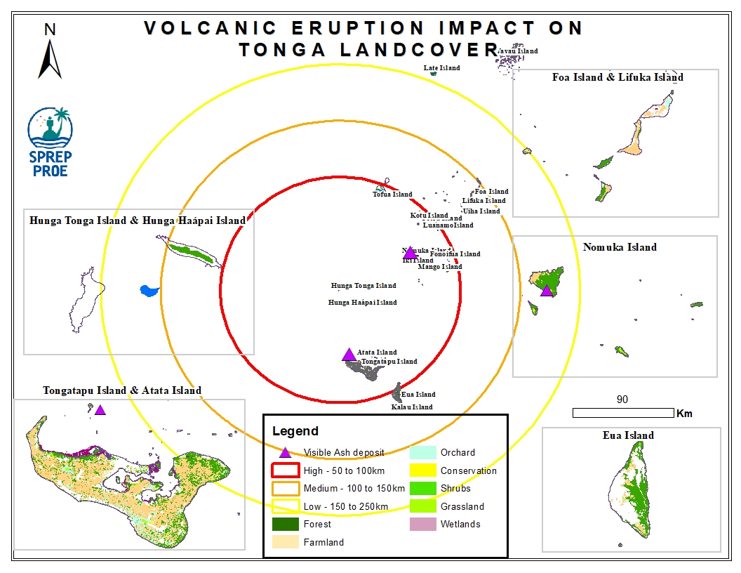
The Hunga Tonga-Hunga Ha'apai massive undersea volcanic eruption occurred on the 15th of January 2022 and led to an induced tsunami event. The eruption triggered a tsunami warning for several South Pacific island nations with rising water levels were reported on the coastline of Peru and the Pacific Coast in the United States and caused devastating impact across Tonga. In addition, volcanic ash residue was also visible on land surfaces including building structures and surrounding vegetation.
This dataset contains preliminary impact assessments of the Hunga-Tonga-Hunga-Ha'apai volcanic eruption and induced tsunami in January 2022.
The eruptions sent a plume of ash, gas and steam 20 kilometers (12.4 miles) into the air. Satellite imagery showed a massive ash cloud and shockwaves spreading from the eruption. Ash was falling from the sky in the Tonga capital, Nuku'alofa, Saturday evening and phone connections were down. The eruption was likely the biggest recorded anywhere on the planet in more than 30 years, according to experts.
This dataset contains all spatial data that is related to the Tonga volcanic eruption. Maps produced are derived from credible data source such as UNOSTAT and UNITAR.
