This zip-file contains the setup file to install QGIS software version 3.4, for a 32 bit system.
The increased demand for high quality products in export markets, coupled with Pacific Island Countries (PICs) national desire to protect the environment, biodiversity and family farming structures, lead to assume that organic agriculture could offer good prospects for PICs development. Besides market opportunities, organic agriculture could increase PICs food self-reliance and thus, contribute to reducing the alarming trend of dependency on food imports, as well as improving nutrition.
End of SPREP internship presentation, July 2015. Sections: climate finance challenges, overview of climate finance in the Pacific, and next steps.
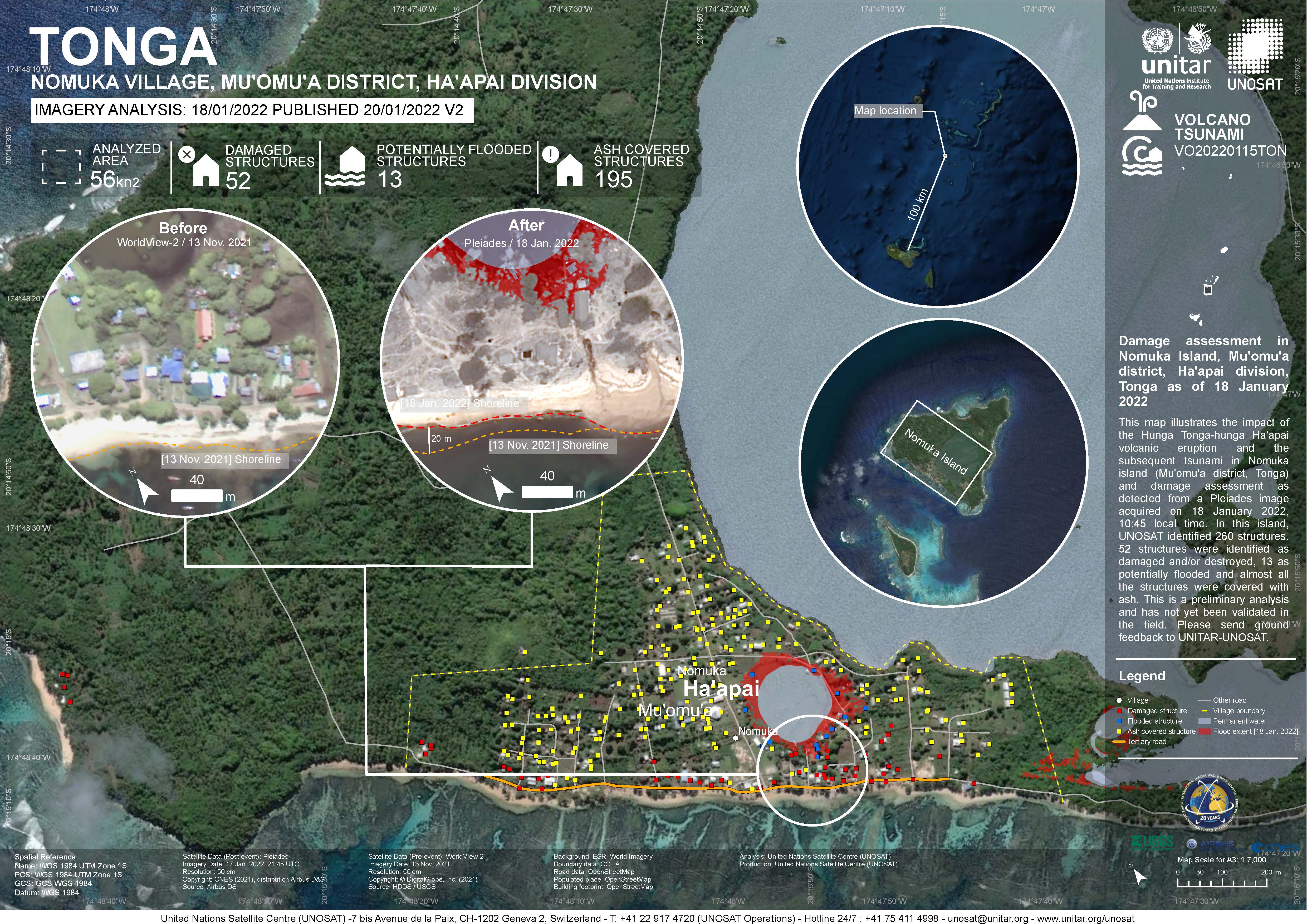
Damage assessment as detected from a Pleiades image acquired on 18 January 2022 in Nomuka Island (Mu'omu'a district, Tonga).
260 structures identified, 52 structures were identified as damaged and/or destroyed, 13 as potentially flooded and almost all structures were covered with ash. This is a preliminary analysis and has not yet been validated in the field

The folder contains GIS data for Atata Island acquired from UNOSTAT. Shapefiles are derived from Pleiades Sensor with data available on Structures impacted Points) and Analysis Extent (Polygon).
The folder contains GIS data for Fonoifua Island acquired from UNOSTAT. Shapefiles are derived from Pleiades Sensor with data available on Structures impacted (Points) and Analysis Extent (Polygon).
The folder contains GIS data for Mango Island acquired from UNOSTAT. Shapefiles are derived from Kompsat3 Sensor, World View 2 Sensor and Pleiades Sensor with data available on Structures impacted (Points), Analysis Extent (Polygon) and Shoreline (Line).
The folder contains GIS data for Nomuka Island acquired from UNOSTAT. Shapefiles are derived from Pleiades Sensor and World View2 sensor with data available on Structures impacted for 17/01, 18/01 (Points), Analysis Extent for 17/01, 18/01 (Polygon), Flood extent, Lake extent (13/11/21 and 18/01/22), Cloud obstruction and SW Shoreline for 13/11/21, 18/01/22.
Buffer distances of 100, 150 and 250km created from the volcanic eruption boundary to identify the level of impacts from the eruption to the resources within the three impact zones.
Map showing reefs with in the different Impact Zones.
This is the Geojson format of the same data in shapefile.
The folder contains GIS data for Eua Island acquired from UNOSTAT. Shapefiles are derived from Pleiades Sensor and World View 3 sensor with data available on Structures impacted (Points), Analysis Extent (Polygon), Cloud obstruction (Polygon) and Shoreline (Lines).
The folder contains spatial data in Geojson format for Tonga Volcanic Eruption Damage Assessment Analysis - Atata Island, Fonifua Island, Mango Island and Nomuka Island acquired from UNOSTAT. Datasets available are Structures impacted (Points), Analysis Extent (Polygon), Cloud obstruction (Polygon) and Shoreline (Lines) which are derived from the Pleiades , Kompsat 3 and World View 3 Sensors.
This new set of 60 indicator icons can be used in a State of Environment report to indicate the status of environmental issues and progress in a country.
A collection of Inform project training materials. You are free to download and use any of the training resources below. The PowerPoint presentations contain a complete set of slides, so please feel free to copy, delete or change slides, to fit the purpose of your country training.
zip file "Pacific_shape_draft15112018", containing all the shape files from the first workshop
The Smithsonian Institution's Global Volcanism Program (GVP) is housed in the Department of Mineral Sciences, National Museum of Natural History, in Washington D.C. We are devoted to a better understanding of Earth's active volcanoes and their eruptions during the last 10,000 years.