OpenStreetMap (OSM) is a free, editable map & spatial database of the whole world. This dataset is an extract of OpenStreetMap data for Tonga in a GIS-friendly format.
The OSM data has been split into separate layers based on themes (buildings, roads, points of interest, etc), and it comes bundled with a QGIS project and styles, to help you get started with using the data in your maps. This OSM product will be updated weekly.
The World Database on Protected Areas (WDPA) is the most comprehensive global database of marine and terrestrial protected areas, updated on a monthly basis, and is one of the key global biodiversity data sets being widely used by scientists, businesses, governments, International secretariats and others to inform planning, policy decisions and management.
FAO Agriculture and Fair Trade in Pacific Island Countries. This desk study has been prepared by Winnie Fay Bell and comments were kindly provided by the Pacific Regional Organic Task Force in May 2009
Shapefiles to be used for the GIS training facilitated by EMG for all staff.
Dates : 8 - 9 November 2021
to be deleted
This is the report for the Reefs at Risk Revisited analysis. Reefs at Risk Revisited is a high-resolution update of the original global analysis, Reefs at Risk: A Map-Based Indicator of Threats to the World’s Coral Reefs. Reefs at Risk Revisited uses a global map of coral reefs at 500-m resolution, which is 64 times more detailed than the 4-km resolution map used in the 1998 analysis, and benefits from improvements in many global data sets used to evaluate threats to reefs (most threat data are at 1 km resolution, which is 16 times more detailed than those used in the 1998 analysis).
This dataset contains GIS data (raster and shapefiles) for the local threats to coral reefs: coastal development, integrated local, marine pollution, overfishing, and watershed pollution.
The Global Mangrove Watch (GMW) is a collaboration between Aberystwyth University (U.K.), solo Earth Observation (soloEO; Japan), Wetlands International the World Conservation Monitoring Centre (UNEP-WCMC) and the Japan Aerospace Exploration Agency (JAXA).
Conservation International, GRID-Arendal and Geoscience Australia recently collaborated to produce a map of the global distribution of seafloor geomorphic features. The global seafloor geomorphic features map represents an important contribution towards the understanding of the distribution of blue habitats. Certain geomorphic feature are known to be good surrogates for biodiversity. For example, seamounts support a different suite of species to abyssal plains.
A video showing how to use some of the key features of the data portal.
Zip file contains a video explaining how to add a dataset for logged-in users
Zip file contains a video explaining how to add additional information for logged-in users.
Zip file contains a video demonstrating a national data portal.
This zip-file contains the setup file to install QGIS software version 3.4, for a 32 bit system.
The increased demand for high quality products in export markets, coupled with Pacific Island Countries (PICs) national desire to protect the environment, biodiversity and family farming structures, lead to assume that organic agriculture could offer good prospects for PICs development. Besides market opportunities, organic agriculture could increase PICs food self-reliance and thus, contribute to reducing the alarming trend of dependency on food imports, as well as improving nutrition.
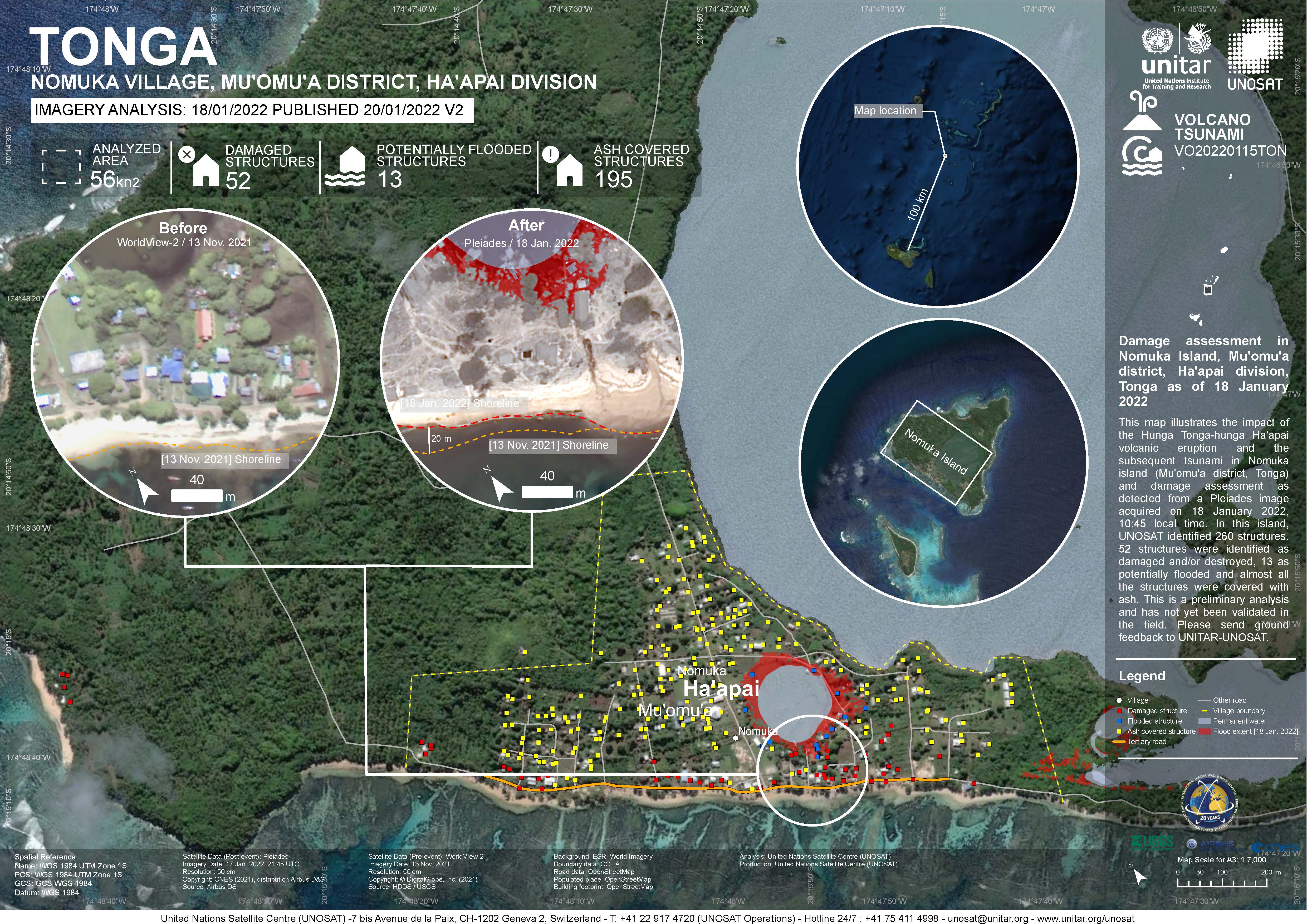
Damage assessment as detected from a Pleiades image acquired on 18 January 2022 in Nomuka Island (Mu'omu'a district, Tonga).
260 structures identified, 52 structures were identified as damaged and/or destroyed, 13 as potentially flooded and almost all structures were covered with ash. This is a preliminary analysis and has not yet been validated in the field

The folder contains GIS data for Atata Island acquired from UNOSTAT. Shapefiles are derived from Pleiades Sensor with data available on Structures impacted Points) and Analysis Extent (Polygon).