Navigating climate change potholes with a mash-up of traditional and bio-technical capacity building.
A ten year road map to reduce Tonga's vulnerability to oil price shocks and achieve an increase in quality access to modern energy services in an environmentally sustainable manner.
Late is an isolated and uninhabited island located about 55 km WSW of the island of Vava’u, in the Kingdom of Tonga. The biological integrity of Late is threatened by invasive Pacific rats that were historically introduced to the island. This report assesses the feasibility of restoring Late through the removal of invasive rats, and describes options, recommendations, and challenges to realizing a successful project.
This report provides design details and costs for the proposed long-term improvements to the water supply
system at Hihifo on the island of Tongatapu, Kingdom of Tonga. This report was part of the demonstration project under the Pacific Adaptation to Climate Change (PACC) programme
Tropical Cyclone Gita hit the main island of Tongatapu and the island of ‘Eua on the night of Monday, 12th February 2018 as a destructive category 4 storm, causing severe damages to these two islands which consists of about 80% of the Total population of Tonga.
This assessment uses the post-disaster data collected by the Statistical Department to describe the characteristics of the affected population, nature and spatial concentration of the damage, and the aid required and received at the time of the interview by the Tongan population.
This is about conservation in Tonga.
Between September 10, 2013 – October 3, 2013 the Khaled bin Sultan Living Oceans Foundation conducted a
research mission to Tonga, focusing on coral reefs surrounding the islands in the Ha'apai group (Sep 11-21),
Vava'u (Sep 22-28) and Niuaatoputapu (Sep 29-Oct 1). The mission included coral reef assessments, coral reef
research, habitat mapping, and educational activities. The objectives of the mission were to:
The Tonga State of the Environment 2018 report has been developed to answer three key questions related
to the environment of Tonga, and is based on seven thematic areas:
• What is the current condition of the Tongan environment?
• What are the risks the Tongan environment faces and what measures have been put forward to minimise them? This could provide lessons for Tonga.
• Where is the environment of Tonga headed based on the assessed thematic areas?
This report outlined the current realities observed the catchment area and the noted area grained from the various implemented activities.
National Invasive Species Strategy and Action Plan 2013-2020
This is a plan for the forests in Tonga.
Status of Fanga'uta in 2015
This is a report of the terminal evaluation
This is a summary of megapode report in Tonga
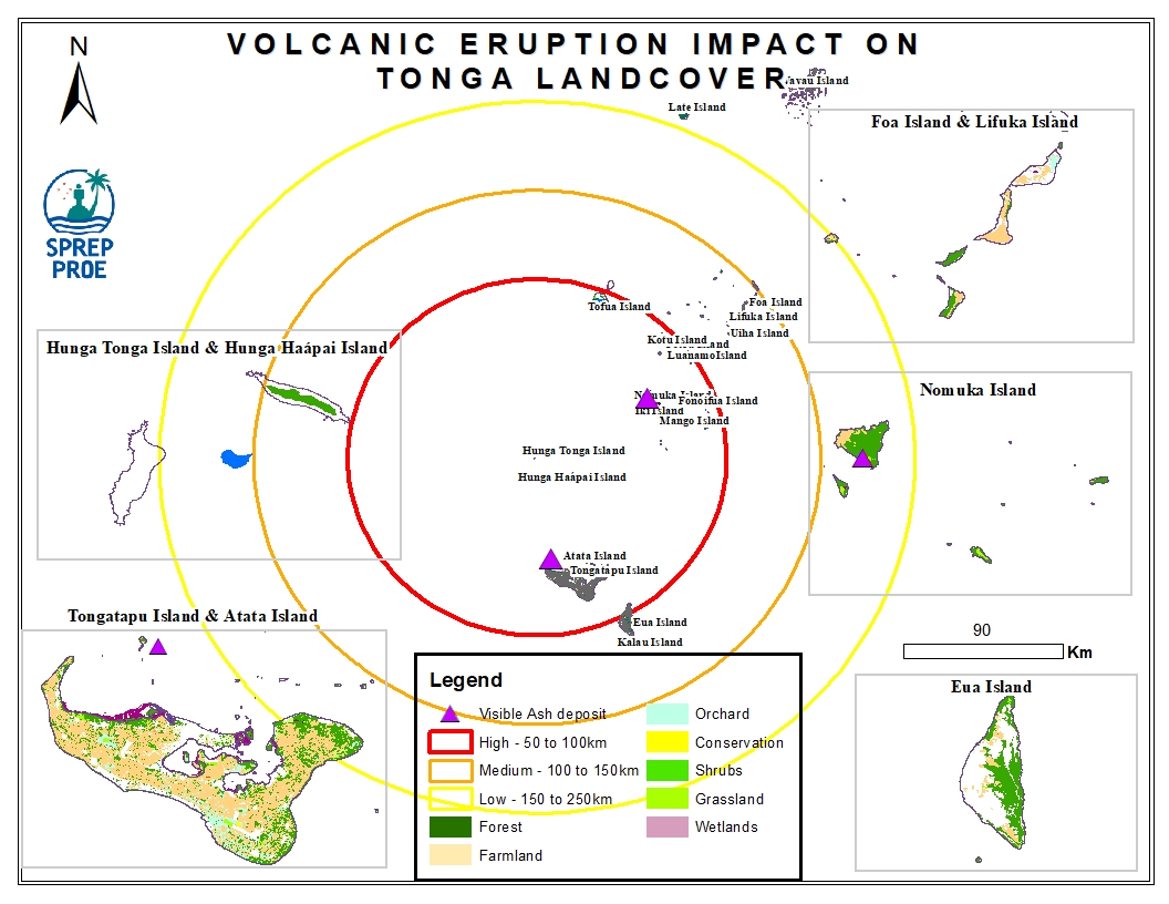
The Hunga Tonga-Hunga Ha'apai massive undersea volcanic eruption occurred on the 15th of January 2022 and led to an induced tsunami event. The eruption triggered a tsunami warning for several South Pacific island nations with rising water levels were reported on the coastline of Peru and the Pacific Coast in the United States and caused devastating impact across Tonga. In addition, volcanic ash residue was also visible on land surfaces including building structures and surrounding vegetation.
This dataset contains all spatial data that is related to the Tonga volcanic eruption. Maps produced are derived from credible data source such as UNOSTAT and UNITAR.
