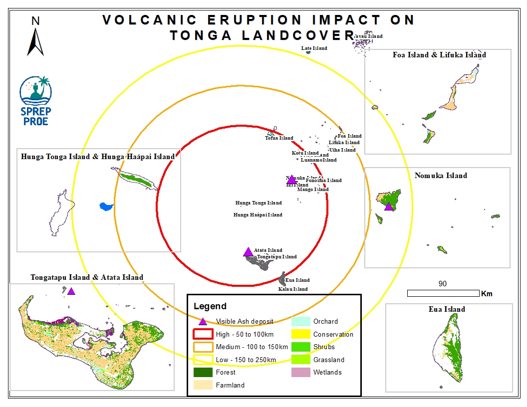
This dataset contains preliminary impact assessments of the Hunga-Tonga-Hunga-Ha'apai volcanic eruption and induced tsunami in January 2022.
The eruptions sent a plume of ash, gas and steam 20 kilometers (12.4 miles) into the air. Satellite imagery showed a massive ash cloud and shockwaves spreading from the eruption. Ash was falling from the sky in the Tonga capital, Nuku'alofa, Saturday evening and phone connections were down. The eruption was likely the biggest recorded anywhere on the planet in more than 30 years, according to experts.
This dataset contains all spatial data that is related to the Tonga volcanic eruption. Maps produced are derived from credible data source such as UNOSTAT and UNITAR.

This publication intends to assist project designers, regulators and decision makers to anticipate and address all relevant public health, socio‐economic and environmental concerns that may arise when under‐ taking a desalination project, for obtaining maximum beneficial use of the desalinated water in terms of quality, safety and environmental protection.
Case study from Kiribati is linked at the bottom of this dataset
"Comparison of the average hard coral cover between the three five-year periods comprising the last 15 years (2005-09, 2010-14, 2015-19, Tab. 9.3) indicated that there was a high degree of confidence (93%) in the long-term decline, despite the uncertainty in individual yearly estimates. Further, the vast majority (90%) of this decline occurred between 2010-14 and 2015-19, suggesting that the rate of decline in hard coral cover has accelerated during the last five years"
Map showing the EEZ of the Pacific
This study reports the concentration of the metals, such as Cd, Co, Cr, Ni, Cu, Pb, Zn, and Fe, in the road dust and the roadside soil of Suva City. A total number of 45 road dust and 36 roadside soil samples were collected at 18 different locations around Suva City with potential traffic influence and analysed.
The purpose of this research is to develop a robust water quality baseline data of relevant physical, chemical and biological parameters, over an 8-month period, 4 months in summer and 4 months in winter, at both low and high tides for three main estuaries along the Suva foreshore, where an increase in recreational water activity has been noted, as a result of urbanisation. Such a baseline is currently not available in the Fiji Islands. This investigation used affordable advanced and approved standard methods.
Information related to the GIS course launch on Wednesday 18th May 2022
Summary table of the status of Pacific Island countries in relation to International and Regional conventions.
First official update and media release following the volcanic eruption from the Government of Tonga, Dated 18th January 2022
This map illustrates the impact of the Hunga Tonga-hunga Ha'apai volcanic eruption and the subsequent tsunami in Fonoifua island located at 110 km NE of Nuku'alofa and also the building damage assessment as detected from a Pleaides image acquired on 20 January 2022.
Preliminary Satellite-Derived Damage Assessment as of 21st January 2022 for 'Eua Island.
Status:
Situation overview for the Tonga volcanic eruption as of 20th January 2022.
Source : United Nations Office for the Coordination of Humanitarian Affairs (OCHA)
Second Official Update and Media Release of the Hunga-Tonga-Hunga-Ha’apai Volcanic Eruption.
This map identifies reefs that falls within each of the 3 Impact Zones